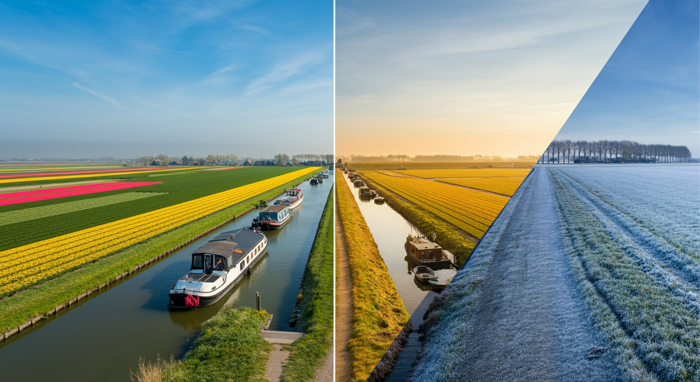
A photograph of a Dutch field taken in late April looks nothing like the same field in January. In April, the polders between Lisse and Hillegom burst into vivid stripes of pink, red, and yellow as the bulb fields reach peak bloom. In January, those same fields are bare brown soil under a flat grey sky. The canal lined with houseboats that appears so distinctively Dutch in a summer photo becomes a frost-edged ribbon of steel-grey water in winter, the leafy trees along its banks reduced to bare silhouettes.
For a human observer, the connection is immediate: it is obviously the same place, just at a different time of year. For an AI geolocation system that matches images on visual features, that variation presents a genuine challenge. And for the researchers, journalists, and verification professionals trying to confirm where a photo was taken, it adds a layer of complexity that goes beyond the simple question of “where?” to include “when, exactly, and what does that tell us?”
What Seasonal Change Actually Does to Dutch Landscape Photography
The Netherlands has a temperate maritime climate, but the visual difference between seasons is striking. The country’s characteristic open polder landscapes, long tree-lined dykes, and large agricultural plots combine to make seasonal transitions highly visible.
Spring brings the tulip fields, a phenomenon essentially unique to this region of the world. A location like the N208 corridor near Hillegom is visually transformed from roughly late March through mid-May. The standard reference imagery in most geolocation databases, typically captured during summer road surveys, does not capture this state at all. A photo taken along that route in April looks fundamentally different from the same location in August, even though the road profile, bridge positions, and building placements are identical.
Autumn strips the foliage from the elms and ash trees that line dyke bodies across the country. Farmhouses that are invisible in summer behind curtains of green stand fully exposed against bare brown fields in November. Dyke crests that appear as green ridges in July become grey, textured earthworks in December.
Winter adds the possibility of high-water events. Low-lying polders can flood temporarily. Fields that are accessible in summer become lakes in January. Some rural paths and small bridges disappear visually behind water. For a system trying to match on what is visible in the frame, this can produce what looks like a completely different scene.
Why Pixel-Level Matching Struggles with This
Early geolocation systems worked by direct image comparison: a query photo was ranked against a catalogue of reference images, and the closest visual match determined the location. This approach has a structural weakness when seasonal variation is involved, because it searches for similarity in raw pixel values, and pixel values shift dramatically with the season.
The same wall on the same street looks different when ivy is growing over it compared to when that ivy has died back. The same canal with the same trees above it casts completely different shadows in June and December. Grass fields near the bulb-growing region change colour across months.
Systems that lean heavily on colour, texture, and vegetation parameters to distinguish locations make more errors in winter than in summer. This is a consistent finding in the visual place recognition literature. Our accuracy benchmarks for GeoPin cover performance variations across different conditions in more depth.
What AI Models Actually Learn
The shift from pixel matching to learned embeddings changes the picture significantly. Modern place recognition models like CosPlace are trained to extract features that persist across visual transformations, including seasonal change.
Rather than asking “do these images look the same?”, the model is trained to ask “do these images share the same underlying spatial structure?” The position of building facades relative to each other, the width of a road, the arc of a bridge over a canal, the angular relationship between a dyke crest and a field boundary: these are the kinds of features that remain consistent regardless of what month the photo was taken.
GeoPin’s reference database includes imagery from multiple seasons, drawn from openly licensed street-level photography that captures Dutch locations at different times of year. The models trained on this data have been exposed to the same locations in summer green and winter grey. That exposure is part of what allows the system to make consistent location predictions even when the query image comes from a season that differs from the dominant reference imagery.
This is not a perfect solution. In highly agricultural areas where structural features are sparse and visual variability is extreme, seasonal change still introduces meaningful noise. But in urban and semi-urban environments where built structures dominate the visual field, performance remains stable across seasons. For a deeper explanation of the underlying technical architecture, our post on how GeoPin works walks through the pipeline in detail.
Practical Implications for Verification Work
For a journalist or investigator who has a photograph of unknown provenance, the seasonal dimension adds both complexity and opportunity.
The complexity: if the system returns a location match in the Gouda area, but the query photo shows a bare, wintry landscape while the reference imagery for that location is lush and green, it can be tempting to read that as a mismatch. It is not. Seasonal difference alone does not invalidate a location match. What you verify instead are the season-neutral features: does the building position match, does the road width match, does the distance to a nearby bridge or canal crossing correspond? If those check out, the seasonal difference confirms you are looking at the same location at a different time of year.
The opportunity: when a photo’s claimed date and its visual seasonal cues do not align, that inconsistency becomes an investigative lead. A photo claimed to have been taken in December that shows full summer foliage and canal boats is internally inconsistent. That inconsistency might indicate a wrong timestamp, a composite image, or deliberately misleading framing around an older photo.
Seasonal cues also interact with light conditions in ways that can help narrow down the time of year more precisely. The angle of shadows, the quality of light, and the presence or absence of frost all constrain the possible date window. This connects to a broader set of challenges around light-dependent verification that we cover in our post on night photography and geolocation challenges.
Seasonal Mismatch as a Manipulation Signal
Once you understand how seasonal features interact with geolocation, you can use mismatches as a deliberate verification layer.
Consider a photo that is circulated with a claim about a recent event in a specific Dutch municipality. The geolocation result places it correctly in that municipality. But the vegetation in the background is in full bloom, and the event is claimed to have occurred in November. The geolocation is not wrong. The date claim might be.
This kind of cross-referencing, pairing location evidence with seasonal visual evidence, is increasingly part of professional OSINT workflows. It does not require specialist knowledge: it requires awareness that the Dutch landscape changes visibly enough between seasons to provide meaningful temporal evidence.
The Broader Picture
AI geolocation for the Netherlands is not a solved problem, but it is a tractable one. The country’s flat, open geography means that structural features in the frame tend to be clearly visible rather than obscured by topography. The country’s density of infrastructure means that distinctive reference points appear frequently. And the fact that Mapillary and similar platforms have extensive Dutch coverage means that GeoPin’s reference database is relatively rich.
Seasonal variation is a genuine challenge to that picture, but one that modern embedding-based approaches handle significantly better than older pixel-comparison methods. For verification professionals working with Dutch imagery, the practical takeaway is clear: treat seasonal difference as information, not as noise. It tells you not just where a photo was taken, but something about when.
Want to add accurate, privacy-first geolocation to your verification workflow? Try the GeoPin API and see how AI geolocation handles the full range of the Dutch landscape, across every season.