The bicycle as a geographic anchor
The Netherlands has more bicycles than people. That is a well-known statistic, but for AI geolocation systems it has a deeper implication: the infrastructure that supports all that cycling is so specific, so consistent, and so ubiquitous that it constitutes one of the strongest visual location signals in the world. Take a photo on almost any street in Utrecht, Groningen or Haarlem and you will almost certainly capture some piece of cycling infrastructure, even if that was not the point of the picture.
Geolocation systems like GeoPin analyse the visual features of an image and compare them against a reference database of geotagged street-level imagery. What makes a visual feature useful? It needs to be distinctive, consistently present, and difficult to confuse with other locations. Dutch cycling infrastructure scores well on all three counts.
Red asphalt: the most recognisable signal
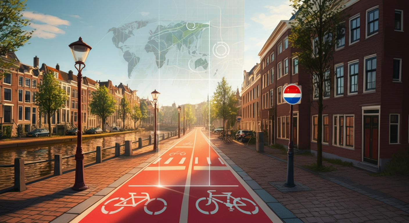
The most immediately noticeable feature is the red asphalt that surfaces Dutch cycle paths. In most countries, bike lanes are indicated with white paint on grey road surface, or not marked at all. In the Netherlands, a dedicated cycle path is almost always surfaced with red or burgundy-red asphalt. This is deliberate: the colour is intended to give cyclists and motorists a clear, persistent visual separation.
For an AI model processing images, this is extremely useful. A red road surface running alongside a carriageway is a strong indicator: this image was probably taken in the Netherlands. Combined with other features, this cue becomes more certain still. Countries like Germany and France do have cycle infrastructure, but rarely with the same colour, width, and consistency as in the Netherlands.
The width of the red path is itself a signal. Dutch cycle paths are designed for two-way traffic and are wide enough to overtake other cyclists. That width creates a particular geometry visible in aerial imagery and in street-level photos taken at oblique angles. A model that has learned this geometry can pick it up even when the colour information is ambiguous or the lighting is poor.
Signs and road markings as a visual fingerprint
The blue circular road signs bearing a white bicycle symbol are particular to the Netherlands and Belgium. They appear with high frequency in street imagery: at every start and end of a compulsory cycle path, at junctions, and on access roads into residential areas. The specific shade of blue, the proportions of the sign, and the mounting height have been standardised across Dutch municipalities for decades.
Road surface markings add another layer. The word “FIETS” or the bicycle pictogram printed on red or grey asphalt appears in a style that differs from comparable countries. The typefaces, proportions and positioning relative to lane dividers are consistent in a way that a well-trained model can learn to recognise.
Traffic lights are also worth noting. Many Dutch junctions have separate traffic lights for cyclists, mounted lower than those for motor vehicles and often with a distinctive capsule-shaped housing. That combination of height, colour and casing design is a subtle but consistent signal.
Canal layouts and urban planning patterns
Dutch cycling infrastructure does not exist in isolation. It is embedded in an urban context that is itself highly recognisable. Cycle paths along canals are one of the most distinctive configurations: a straight quayside, red or grey paving, a row of trees, brick canal houses on the opposite bank, and the water surface. This pattern, repeated across Amsterdam, Utrecht, Haarlem, Delft and dozens of smaller cities, forms a visual signature that is difficult to imitate or confuse with anywhere else.
Outside the canal cities, comparable patterns appear in polder landscapes: cycle paths along straight drainage canals, dykes and water management works. The combination of flat terrain, waterway, vegetation, and bike path is recognisable as specifically Dutch spatial planning even from an apparently generic countryside photo.
Even in suburban areas that might otherwise seem generic, there are signals. The “fietsstraat” concept, a residential street surfaced entirely in red with cars as guests, has been implemented far more extensively in the Netherlands than anywhere else in Europe. A photo of such a street produces a cluster of features that together constitute a strong location hint.
How GeoPin combines these signals
When you upload a photo to GeoPin, the system runs through several stages. First, it generates a visual embedding using CosPlace, a model trained specifically for visual place recognition. That embedding captures the spatial identity of the scene: not just what is in it, but how the elements are arranged relative to each other.
The embedding is then compared against millions of reference images in our database of Dutch street-level imagery. That database is assembled from multiple sources, including Mapillary, and is structured so that cycling infrastructure is systematically covered. You can read more about how the database was built in our article on building the Netherlands reference index.
Once the initial candidates are selected, geometric verification follows using LightGlue feature matching. This is the step where cycle path markings, kerb configurations and road signs act as concrete anchor points. Two photos taken at the same cycle path junction share specific geometric relationships between the road marking, the sign position and the carriageway angle. Those relationships are hard to fake and straightforward to verify.
The result is a location estimate with a confidence score. In areas with rich cycling infrastructure, that score tends to be higher, because the database contains more distinctive reference imagery and the search finds more matching anchor points. You can see how this translates into accuracy figures in our benchmark analysis.
Privacy and detecting location without identifying people
A fair concern with geolocation technology is how it handles the privacy of people who appear in photos. GeoPin operates at the scene level, not the person level. Our system analyses the built environment: road markings, architecture, signage, vegetation. Faces and licence plates are not inputs to our models and are not stored.
This is not only a technical choice but a principled one. In a country where the GDPR is enforced seriously, privacy by design is not a marketing phrase but a baseline requirement. Cycling infrastructure as a location signal fits this model perfectly: it is impersonal, stable over time, and legally uncomplicated to process. We cover our approach to this in more detail in the article on privacy-first geolocation and the GDPR.
The practical implication for users is that GeoPin can verify where a photo was taken without needing to identify any individual in the image. For OSINT analysts, journalists and verification professionals, this is a meaningful distinction. You get the location answer you need without the legal and ethical complications that come with facial recognition or personal data processing.
An unexpected benefit of dense infrastructure
There is an interesting asymmetry in geolocation work: the more consistently structured an area is, the easier it is to localise. The Netherlands, with its extremely standardised cycling infrastructure deployed across the entire country, is therefore one of the most localisable countries in the world based on street-level imagery.
This is useful for OSINT investigators who need to verify where a photo was taken. It is useful for journalists placing images. And it is useful for businesses that need to understand the geographic context of an image without relying on metadata that may have been stripped or manipulated.
The density of the Dutch cycling network also means that almost any outdoor photo taken in the Netherlands will contain at least one infrastructural cue that a well-calibrated model can use. That redundancy makes the system robust: even if one feature is obscured or ambiguous, others are likely visible.
The question of how Mapillary imagery contributes to this coverage is explored in our article on how Mapillary powers GeoPin’s reference database. The short version is that the Netherlands is one of the most densely covered countries in Mapillary’s dataset, precisely because so many Dutch cyclists and pedestrians have contributed street-level photos over the years.
Try GeoPin
Curious how accurately our system can place a street-level photo using visual cues alone? Upload an image at geopin.nl and see how cycling infrastructure contributes to a precise location estimate. For questions about integration or business use, get in touch via the contact form on the website.